When we try to understand why Metro Manila is slowly dying from motor vehicle traffic, some ideas resurface in every conversation. “Bad urban planning,” “poor public transport” and “too many cars” are among the ones that come up over and over again. I don’t think anyone will disagree with these statements about Manila, but if we want to solve these problems, we have to go a little deeper. In my work as a local transport planner, I believe it’s important to ask the component questions of different policies:
Why did we do this?
What did we do to get here?
Knowing the history of policy is important to properly answer the third, relevant question:
What do we do to get out of this mess?
Back in 2013, the Copenhagenize Design Company posted an image that, I feel, speaks a lot to how we got into the traffic hell we’re in. I’ve been using it in my presentations for a while, but since some friends recently asked me to explain it to them, this piece is dedicated to this picture:
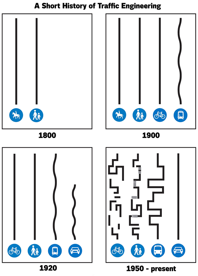
“So, what do the lines mean, Rob?”
Each of the lines symbolizes the shapes taken by different modes of travel throughout history. For a long time, we designed cities so that pedestrians, cyclists and transit could get to where they were going in a straight line, or a small number of straight lines. This makes mathematical sense: The shortest distance between two points is a straight line, and so when people want to travel, they travel in straight lines (hold on to that thought because it’s key to understanding the rest of the graphic). To understand this type of planning a little bit better, pay attention to the design of old Manila, or districts that are of similar age or older in other cities. It has small blocks laid out in a fine-grained grid of streets, so that pedestrians can easily find their way around by walking in just two straight lines.
As technologies (such as bicycles and trams) were developed, the straight lines of travel from origin to destination—referred to by planners as “desire lines”—were preserved, and the design of cities from this time reflects that. Even after cars had been introduced in the early 20th century, the road—and the design of cities—still belonged to people of all modes, at least for a time.
For cars to reach their maximum speed in straight lines, city planners made pedestrians and cyclists get out of the way
However, in 1927, Henry Ford’s 15,000,000th Model T hit the streets, and by then a new vision of reality had set in: Everyone would be able to own inexpensive, mass-produced cars. Traffic engineers and city planners adopted a new vision—everyone getting around in cars as fast as possible. Cars demanded their straight lines as well, but now there were some differences. Planners figured that the other modes of travel were due to go the way of the horse and the buggy, so they started designing as if walking, cycling and transit were afterthoughts.
For cars to reach their maximum speed in straight lines, planners made pedestrians and cyclists get out of the way. They were allowed their “safe” travel, yes, as long as they didn’t interrupt the sacred path of cars. Pedestrian crossings were reduced in number and sometimes shunted upward in overpasses, which means walking was now longer, more circuitous and less convenient. Bicycles? Maybe there was space for people to bike for “fitness” in their neighborhoods, but no one was seriously still going to use these to get to work, right? The once-safe paths and junctions for bicycles were expanded to accommodate automotive speeds, “bullying” bicycles off the road.
Buses and road transit still followed continuous paths, but they often had to deviate due to “No Bus” and “No PUJ” restrictions on essential pathways. Forcing buses to run in confusing, deviating paths made transit more vulnerable to traffic delays, and made road transit systems more confusing. A bus that has to make constant turns means a less comfortable ride for those inside, further degrading the transit experience. Transit expert Jarrett Walker stresses the importance of linearity of transit lines: Straight transit lines mean service that is simpler to understand, more affordable to operate, and faster to ride. Poor route geometry is one reason that our public transport “sucks.”
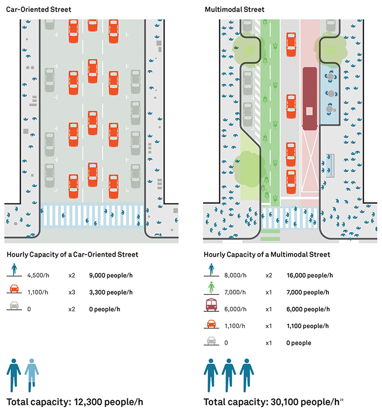
This is one (trust me, there are more) major root of our problems. We have effectively designed cities to tell bikers, pedestrians and transit riders to “get out of the way” so that cars can go as fast as possible. Never mind that cars actually carry the lowest capacity—measured in persons per hour per direction, for the same space—compared to the other travel modes they have displaced. The snag is that if everyone wants to drive a car at the same time—meaning if everyone wants to use the least space-efficient transport mode at the same time—we quickly run out of space for anyone to move fast, leaving our streets congested.
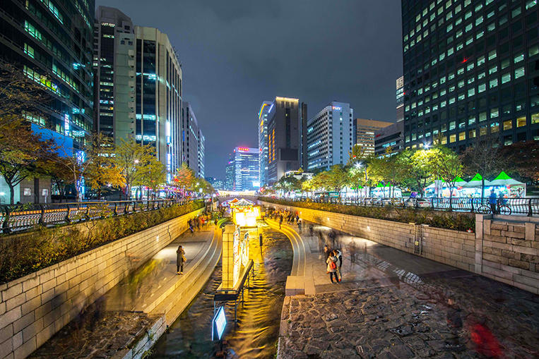
Thankfully, it’s possible to undo the effects of past design choices. All over the world are famous examples of undoing car-centric design to allow pedestrians, cyclists and transit riders to share the road—and our urban space—a bit more as well. One of the most famous feats of this kind is when the Seoul Metropolitan Government demolished a highway to create the Cheonggyecheon stream and linear park, which revitalized urban life in Seoul.
It may be long before we can convince anyone to bring down highways in Metro Manila. But next time you feel trapped in your car—wishing you could walk, bike or take transit safely—just remember that someone made the choice to make things this way, and someone can (and hopefully will) make the choice to make things better in the future. History (and a little hope) will show us the way out of this traffic nightmare.
Comments